Sandgerði
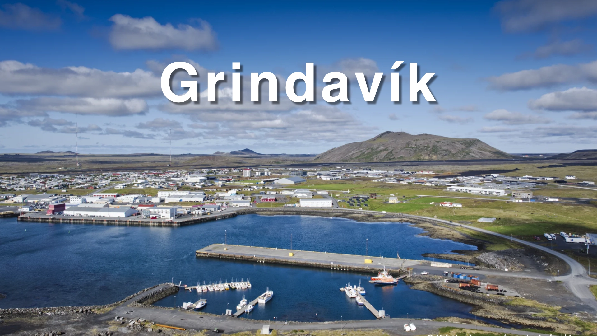
Sandgerði stands on the western side of the Reykjanes peninsula, facing the open Atlantic across a low coast of reefs, skerries and shallow water. Fishing remains central to the town, and the harbour is its most important physical and economic feature.
The surrounding coast has also shaped Sandgerði through repeated loss. Básendar, south of the town, was a trading port for more than three centuries before a sea flood destroyed it in January 1799. At Stafnes in February 1928, the trawler *Jón forseti* ran onto a reef during severe weather. Ten of the twenty-five crew were rescued, while fifteen died.
Slysavarnafélag Íslands had been founded one month before the wreck. The disaster accelerated the creation of local rescue divisions, and Sigurvon was established in Sandgerði in June 1928 as the first division within the national association. The distinction matters because an earlier rescue association had existed in Vestmannaeyjar. Sandgerði’s place in the story is nevertheless substantial: this was where the new national organisation began building its local network.
The history of this coast is not entirely a history of loss. In 1940, the Sandgerði motorboat *Kristján* disappeared after becoming disabled at sea. Its five-man crew was presumed dead, and a memorial service was being prepared. After twelve days of drifting, the boat reached land at Skiptivík near Merkines. The men had survived partly by distilling drinking water from seawater.
The fullest account was written by Þorvaldur Steinason, who worked ashore baiting the hooks for *Kristján* after injuries prevented him from continuing as a fisherman. His story connects the survival of the crew with the people in Sandgerði who worked for the boat and waited for its return.
The town’s relationship with the sea also appears in Þekkingarsetur Suðurnesja, where natural-history collections, marine research and exhibitions bring the life of the surrounding coast indoors. Together, the working harbour, rescue history, survival of *Kristján* and science centre present a town that has depended on the sea while learning to understand and respond to it.
Sandgerði is best treated as a short stop. The harbour and science centre are the principal places to visit. Stafnes and Básendar lie farther south and are reached by driving rather than by following a continuous coastal walk from the town.
The location of Sandgerði
Latitude
64.0342
Longitude
-22.7010
Sandgerði
The working harbour
Sandgerði developed as a fishing settlement during the second half of the 19th century. The transition from rowing boats to motorised vessels increased the need for a protected harbour and allowed fishing to support a more permanent concentration of homes and services.
Building protection on this coast has required repeated work. The natural approach is shallow and broken by reefs and skerries, while the western exposure allows heavy seas to reach the shore. Harbour improvements continued through much of the 20th century, with substantial rock structures added from 1974 to provide better protection against the Atlantic swell.
Fishing still strongly defines Sandgerði. Boats, quays, harbour buildings, equipment and protective structures are not remnants of an earlier economy arranged for visitors. They form an active workplace and the clearest expression of the town’s purpose.
The harbour should therefore be the starting point for understanding Sandgerði. It shows the practical response to the same coast described throughout the town’s history. Where earlier generations relied on difficult natural landing places, modern Sandgerði has constructed and repeatedly reinforced a harbour capable of supporting commercial fishing.
Visitors should remain in public areas and keep clear of working quays, vehicles and equipment. The harbour is visually accessible, but its operations take priority over sightseeing and photography.
Sandgerði and Miðnes
The older geographic name Miðnes remains important to the history of Sandgerði. It refers to the western part of Rosmhvalanes and to the coast extending south from Garðskagi past Sandgerði, Hvalsnes and Stafnes.
Rosmhvalaneshreppur was divided in 1886. The western area became Miðneshreppur, while the other part retained the older municipal name and included Garður, Leira and Keflavík. The division formalised a distinction between communities that were already developing around different fishing places and coastal connections.
Miðneshreppur received town status in 1990 and was renamed Sandgerðisbær. That municipality existed until 2018, when Sandgerðisbær and Sveitarfélagið Garður merged to form Suðurnesjabær.
Sandgerði and Garður now belong to the same municipality, but they remain distinct destinations. Garður’s principal visitor landscape is Garðskagi, with its lighthouses, birdlife and broad coastal views. Sandgerði is more clearly defined by its working harbour and by the difficult shore extending south towards Hvalsnes, Stafnes and Básendar.
The older name Miðnes helps connect these places. It describes a coastal district rather than only the modern town, and it provides the correct geographical setting for the fishing stations, trading sites and wrecks that shaped Sandgerði.

Básendar and the flood of 1799
Básendar lie south of Sandgerði between Stafnes and Hafnir. Little remains above ground, but the site was once one of the principal trading places on the western Reykjanes coast.
Trade took place at Básendar from at least 1484. During the Danish trade monopoly, it was one of the licensed ports serving Hafnir, Stafnes and Miðnes. Its harbour was a long, narrow lagoon reached through a difficult approach between reefs.
The settlement included the merchant’s residence, warehouses, smaller homes and buildings connected with fishing and trade. Hinrik Hansen, the last merchant at Básendar, lived there with his family when the disaster occurred.
During the night leading into 9 January 1799, an exceptionally severe storm and high sea level drove water across the settlement. The sea entered the merchant’s house with enough force to fill its lower rooms, forcing the family and servants into the loft. As the building began to fail, they escaped through a window and crossed flooded ground to higher buildings.
Other residents escaped through the roofs of their homes. One person, the 79-year-old Rannveig Þorgeirsdóttir, died in the flood. Contemporary assessments indicate that the sea travelled approximately 174 metres inland beyond the upper buildings of the trading place.
Most of the structures were destroyed or severely damaged. Boats, stored goods, household possessions and fishing equipment were lost. The same storm caused extensive damage elsewhere around southern and western Iceland, but Básendar became its defining location because the entire trading settlement was abandoned.
Básendar was never rebuilt. Hinrik Hansen moved to Keflavík, and more than three centuries of trade ended in one night. The remaining wall lines and foundations are protected archaeological remains. Visitors should walk beside them rather than across them, even where the structures appear little more than low stones in the ground.
The wreck of Jón forseti
At about one in the morning on 27 February 1928, the trawler Jón forseti struck the reef Kolaflúð off Stafnes. The ship carried a crew of twenty-five and had been one of the most important vessels in the development of Icelandic trawler fishing.
Conditions made rescue from land exceptionally difficult. There was no road or telephone connection at Stafnes, and the people who reached the shore had little specialised equipment. Boats sent from Sandgerði could not approach the stranded trawler safely through the breaking sea.
The crew managed to send a line and small boat towards land. Nine men were brought ashore by this method. When it could no longer be used, two of the remaining men entered the sea. One, Frímann Helgason, reached land alive. Ten men survived altogether, while fifteen died.
Slysavarnafélag Íslands had been founded on 29 January 1928, approximately one month before the wreck. The loss of Jón forseti did not cause the national association to be founded, as is sometimes stated. It demonstrated the urgent need for trained local groups, communications and rescue equipment around the coast.
Sigurvon was established in Sandgerði on 23 June 1928. It became the first local rescue division created within Slysavarnafélag Íslands and the beginning of the association’s network of coastal divisions.
A memorial at Stafnes records the loss of Jón forseti and the people involved. Its location gives the event a physical connection to the coast where it happened, but visiting it requires a separate drive south from Sandgerði.
When Kristján came ashore
In February 1940, the motorboat Kristján left Sandgerði with five men aboard. After the vessel became disabled, it drifted at sea for twelve days without contact with land. As the days passed, the boat and everyone aboard were presumed lost.
The crew faced a shortage of drinking water. One of the men knew enough about distillation to improvise a method of producing fresh water from seawater. Material from the boat was used as fuel to keep the process operating. The amount produced was limited, but it helped keep the five men alive through the final days of the drift.
In Sandgerði, the loss was treated as certain. A memorial service was arranged for the crew. Instead, on 1 March 1940, Kristján reached land at Skiptivík near Merkines in Hafnir. The memorial service was due to take place the following day. The priest who had expected to conduct it sent the surviving men a telegram of congratulations instead.
The most important account of the event was written by Þorvaldur Steinason. He had worked as a fisherman until injuries prevented him from continuing at sea. He then became one of Kristján’s shore workers, baiting the hooks and preparing the longlines used by the boat.
His relationship to the story was therefore direct. He knew the vessel, its work and the people waiting in Sandgerði. In his 1972 account, he wrote that only a few hours separated Kristján’s arrival from the point at which the shore workers would have left Sandgerði after accepting that the boat was gone.
The return of Kristján provides an essential counterpoint to Básendar and Jón forseti. The same exposed coast that produced stories of destruction also preserved one of Sandgerði’s most remarkable stories of endurance, practical knowledge and survival.
Marine science in Sandgerði
Þekkingarsetur Suðurnesja, the Suðurnes Science and Learning Centre, brings together natural-history exhibitions, education and scientific work. It shares its building with the University of Iceland Research Centre in Suðurnes and Náttúrustofa Suðvesturlands.
The collections reflect the natural environment of the peninsula. They include marine specimens gathered from the waters around Sandgerði, living animals in aquaria, mounted birds and collections of eggs, plants, stones and insects. The displays allow visitors to examine organisms that would otherwise remain hidden beneath the water or be seen only at a distance along the shore.
The centre is particularly suitable for children because the displays provide a direct introduction to marine animals, birds and the ecology of Reykjanes. It also differs from a conventional local museum because active research and environmental monitoring continue in the same building.
Another exhibition, Heimskautin heilla, concerns the French physician, scientist and polar explorer Jean-Baptiste Charcot. Reconstructed sections of a ship’s bridge and cabin help present his expeditions and his connection with Iceland and Franco-Icelandic relations.
The science centre is the principal indoor visitor experience in Sandgerði. Current municipal information lists regular public opening from 2 May until 31 August, with the exhibitions closed outside that period unless arrangements are made for a group. These details should be checked before travelling because access and seasonal schedules may change.
A short stop and a coastal drive
Sandgerði is a short-stop destination rather than a base or a place requiring a fixed amount of time. The harbour alone can be seen relatively quickly, while including Þekkingarsetur Suðurnesja naturally extends the visit. The science centre’s seasonal opening also changes what the town offers at different times of year.
The harbour and science centre are the principal places to see within Sandgerði. The surrounding historical sites should be understood as part of a driving route rather than as one continuous shore walk.
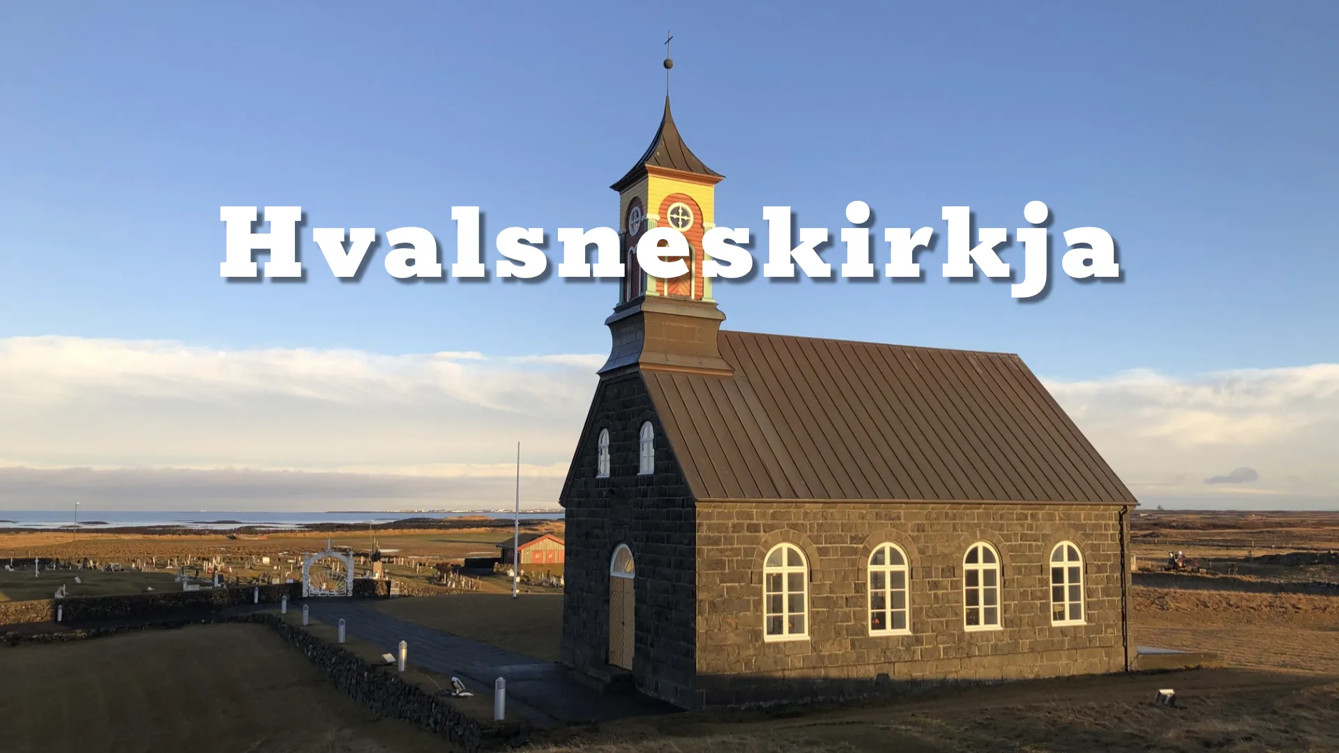
Hvalsneskirkja stands south of the town and has its own destination page. Continuing farther leads towards Stafnes, the Jón forseti memorial and the ruins of Básendar. Stops require individual access from the road, and visitors should not assume that the shoreline provides a marked or practical walking route between them.
This method of travelling suits the character of the coast. Each stop reveals a different aspect of Miðnes: the modern fishing harbour at Sandgerði, religious and cultural history at Hvalsnes, organised rescue history at Stafnes and the remains of centuries of trade at Básendar.
Dramatic weather gives the clearest sense of why the harbour and rescue history matter. That does not require approaching the water closely. Waves breaking across reefs and protective harbour structures are best observed from secure public ground, particularly when wind and spray make the shore difficult.
Interesting facts:
- Sandgerði had 1,990 residents in 2024.
- Fishing remains one of the defining activities of the town.
- The western part of Rosmhvalaneshreppur became Miðneshreppur in 1886.
- Miðneshreppur was renamed Sandgerðisbær when it received town status in 1990.
- Sandgerðisbær and Sveitarfélagið Garður merged to form Suðurnesjabær in 2018.
- Básendar was a trading place from at least 1484.
- A sea flood destroyed Básendar during the night leading into 9 January 1799.
- One person, Rannveig Þorgeirsdóttir, died in the Básendar flood.
- Básendar was never rebuilt after the disaster.
- Jón forseti struck a reef off Stafnes on 27 February 1928.
- Ten members of its twenty-five-man crew survived, while fifteen died.
- Slysavarnafélag Íslands had been founded approximately one month before the wreck.
- Sigurvon became the first local rescue division established within Slysavarnafélag Íslands.
- In 1940, the Sandgerði motorboat Kristján drifted without power for twelve days.
- Its five-man crew survived partly by distilling drinking water from seawater.
- A memorial service was scheduled for the day after the crew unexpectedly returned.
- The principal account was written by Þorvaldur Steinason, who worked ashore baiting Kristján’s longlines.
- Þekkingarsetur Suðurnesja combines visitor exhibitions with active scientific work.
Image Gallery


Photography tips:
- The harbour is Sandgerði’s strongest photographic subject. Use boats, working structures and the protective rock barriers to show why the settlement developed here.
- Dramatic weather suits the harbour and exposed coast. Breaking water, spray and low cloud make the relationship between the town and sea more visible.
- A fast shutter speed preserves the form and force of waves breaking across the reefs. A slightly slower exposure can retain movement without reducing the sea to featureless mist.
- A moderate telephoto lens is useful for isolating boats and compressing the harbour structures against rough water.
- Wider compositions should include both the harbour and the open sea so the protective function of the structures remains clear.
- Photograph from public areas and remain clear of loading activity, vehicles, ropes and working quays.
- At Stafnes, include the sea and offshore reef when photographing the Jón forseti memorial. The setting explains why the memorial stands there.
- Básendar requires restrained compositions because the archaeological remains are low. Use the coastline and open ground to establish their location rather than approaching or standing on the foundations.
- In strong wind, use a stable stance and protect the camera from salt spray. Avoid exposed edges and low shore ground when waves are reaching inland.
- A long lens allows dramatic surf to be photographed from a safe position without moving closer to the water.
Destinations nearby