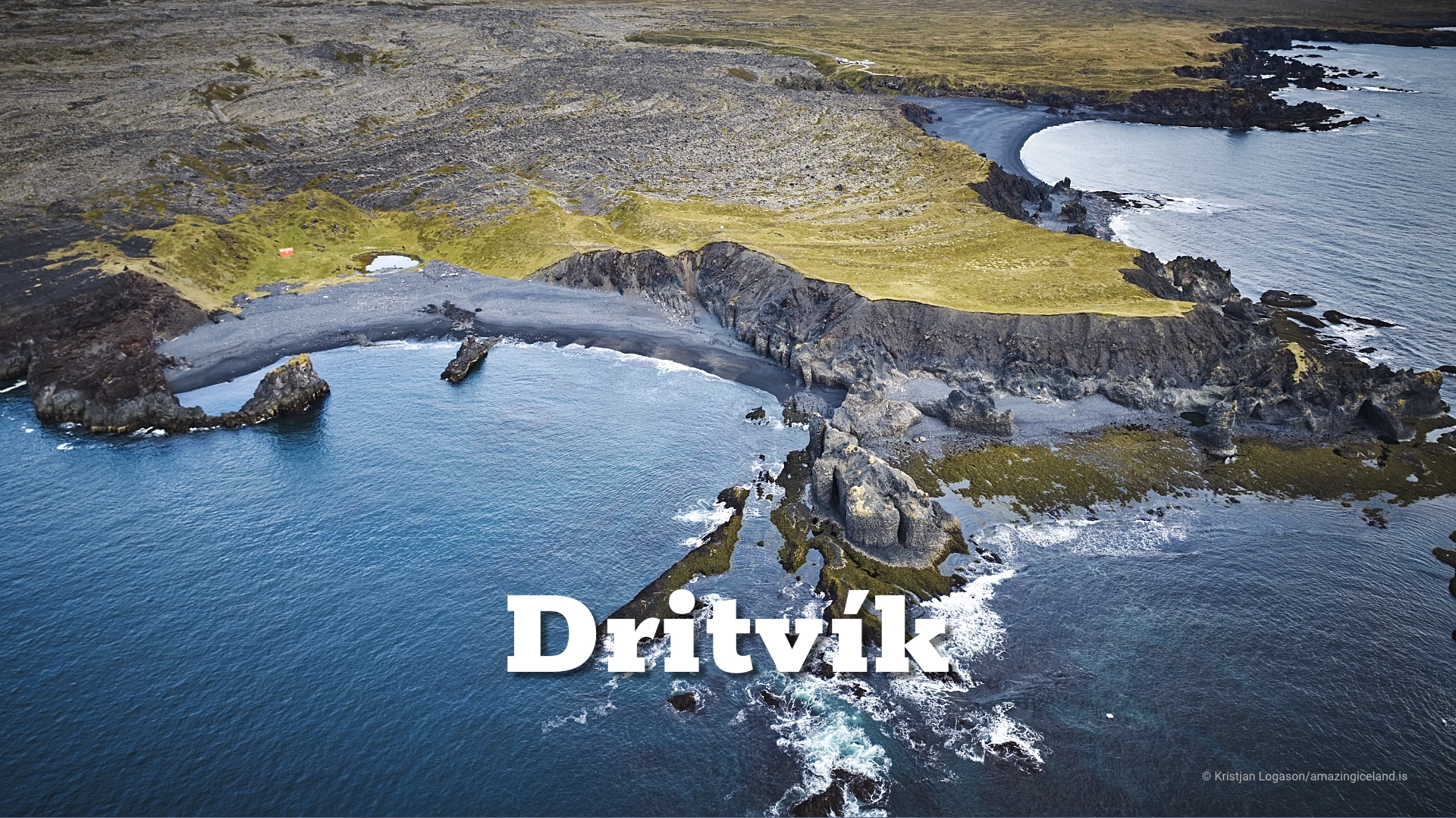
Dritvík bay on Snæfellsnes peninsula
Dritvík is a small bay at the western tip of the Snæfellsnes Peninsula, reached on foot from Djúpalónssandur. Today it looks almost empty.
Three centuries ago, during the fishing season, the same bay could hold dozens of open boats and several hundred people. Dritvík was one of Iceland’s largest seasonal fishing stations, and its importance came from something very practical: compared with the neighbouring pebble beach at Djúpalónssandur, Dritvík offered a more workable sandy landing place where boats could be hauled ashore.
Very little of that seasonal settlement is obvious today. The surviving remains are low and easy to overlook, but once the history is understood, the bay becomes much easier to read.
The location of Dritvík bay on Snæfellsnes peninsula
Latitude
64.7536
Longitude
-23.9144
Dritvík bay on Snæfellsnes peninsula
A seasonal town without a harbour
From the sixteenth century and well into the nineteenth, Dritvík developed into one of Iceland’s major seasonal fishing stations. The exact numbers vary between sources, but at its busiest there were roughly 40–60 boats working from the bay and perhaps 200–600 people staying here during the fishing season.
This was not a permanent village. The population increased rapidly when the fishing season began and declined again when it ended.
For centuries, this seasonal rhythm was normal around much of the Icelandic coast. Men travelled to fishing stations for the months when cod fishing was at its most important, working from open boats in conditions that depended entirely on weather, sea state and the quality of the landing place.
Dritvík became one of the largest of those temporary communities. For part of each year it functioned almost like a town, even though very few people lived there permanently.
Hauling the boats ashore
There was never a harbour at Dritvík. Boats were launched directly from the beach and dragged ashore again after returning from sea.
That makes the physical character of the bay central to its history. Dritvík contains considerably more sand than nearby Djúpalónssandur, where rounded black pebbles dominate much of the shoreline.
A sandy beach made landing and hauling open boats considerably easier. It helps explain why Dritvík became the major fishing station while Djúpalón, only a short distance away, did not develop on the same scale.
Standing on the beach today, it is useful to imagine rows of boats pulled clear of the water rather than a harbour full of moored vessels. The entire fishing operation depended on the ability to launch and recover boats from this exposed shore.

Life in the verbúðir
The fishermen staying at Dritvík lived in temporary stone-and-turf dwellings known as verbúðir. Historical and archaeological records indicate that there were at least nine verbúðir at Dritvík in the early eighteenth century.
These were practical seasonal dwellings rather than permanent farmhouses. Men lived close together for the duration of the fishing season, working long days at sea and processing the catch after returning to shore.
Fish was cleaned, prepared and dried as part of the wider stockfish economy that shaped much of Icelandic coastal life for centuries.
Very little of the settlement is immediately obvious today. Only a few low ruins can still be recognised in the landscape, and they are easy to miss if you expect substantial standing buildings.
That modest scale is part of the experience. The remains do not reconstruct Dritvík or make the old fishing station easy to visualise. They simply mark where it once stood.
The decline of Dritvík
The importance of seasonal fishing stations such as Dritvík declined during the nineteenth century. Fishing technology changed, processing changed and permanent coastal settlements with better landing facilities and, eventually, harbours became increasingly important.
The older system of travelling to exposed seasonal stations became less practical. As larger settlements developed stronger infrastructure, places such as Dritvík gradually lost the function that had once drawn hundreds of people to them.
What remained was the landscape, the landing beach and the low traces of the temporary settlement.
The contrast is considerable. A bay once crowded with fishermen, boats, gear and drying fish now gives almost no immediate indication of that activity unless you know the history.
That contrast between past intensity and present emptiness is one of the strongest aspects of Dritvík.
Walking to Dritvík
There is no road to Dritvík. The usual approach is on foot from Djúpalónssandur, where the parking area and main visitor access are located.
The official route is approximately 1 kilometre and normally takes around 20 minutes. The walk crosses the lava landscape between the two bays.
Older waymarkers have been lost in bad weather, so the route should not be treated as continuously marked. Anyone walking to Dritvík should be comfortable following the terrain rather than relying entirely on markers.
The short distance can make the bay seem easy to reach, but the landscape still feels isolated once Djúpalónssandur disappears behind you. That change in atmosphere helps explain why Dritvík works so well as a historical site.
Djúpalónssandur has its own destination page covering the car park, lifting stones, the wreck of the Epine and the safety considerations around the exposed beach.
Interesting facts:
- Dritvík was one of Iceland’s largest seasonal fishing stations.
- At its busiest, roughly 40–60 boats and perhaps 200–600 people worked from the bay.
- There was no harbour. Boats were hauled directly onto the beach.
- The sandy shore made Dritvík easier to use as a landing place than neighbouring Djúpalónssandur.
- Fishermen lived in temporary stone-and-turf dwellings called verbúðir.
- At least nine verbúðir were recorded at Dritvík in the early eighteenth century.
- Very few of the old structures remain clearly visible today.
- Dritvík is reached on foot from Djúpalónssandur.
- The walk is approximately 1 km and normally takes about 20 minutes.
Image Gallery


Photography tips:
- Let the history give scale to the landscape. Dritvík works better as a place of absence and memory than as a dramatic landmark.
- Use wider compositions to include the low ruins within the bay rather than trying to isolate them as architectural subjects.
- Include the sandy landing beach whenever possible. It is the key to understanding why Dritvík became such an important fishing station.
- The emptiness of the bay is useful photographically. A strong image does not need to make Dritvík look spectacular; the contrast between what is visible now and how crowded it once became is the more interesting idea.
- Longer focal lengths can help compress the beach, ruins and surrounding lava, while wider lenses are better for showing the full scale of the bay.
- Overcast or broken light often suits the site because it keeps the mood subdued and allows detail to remain visible in the dark lava and low ruins.
- Include parts of the walk from Djúpalónssandur when building a photographic sequence. The sense of moving away from a busy visitor site into a quieter historical landscape is part of Dritvík’s character.
Destinations nearby