Þorvaldseyri farm
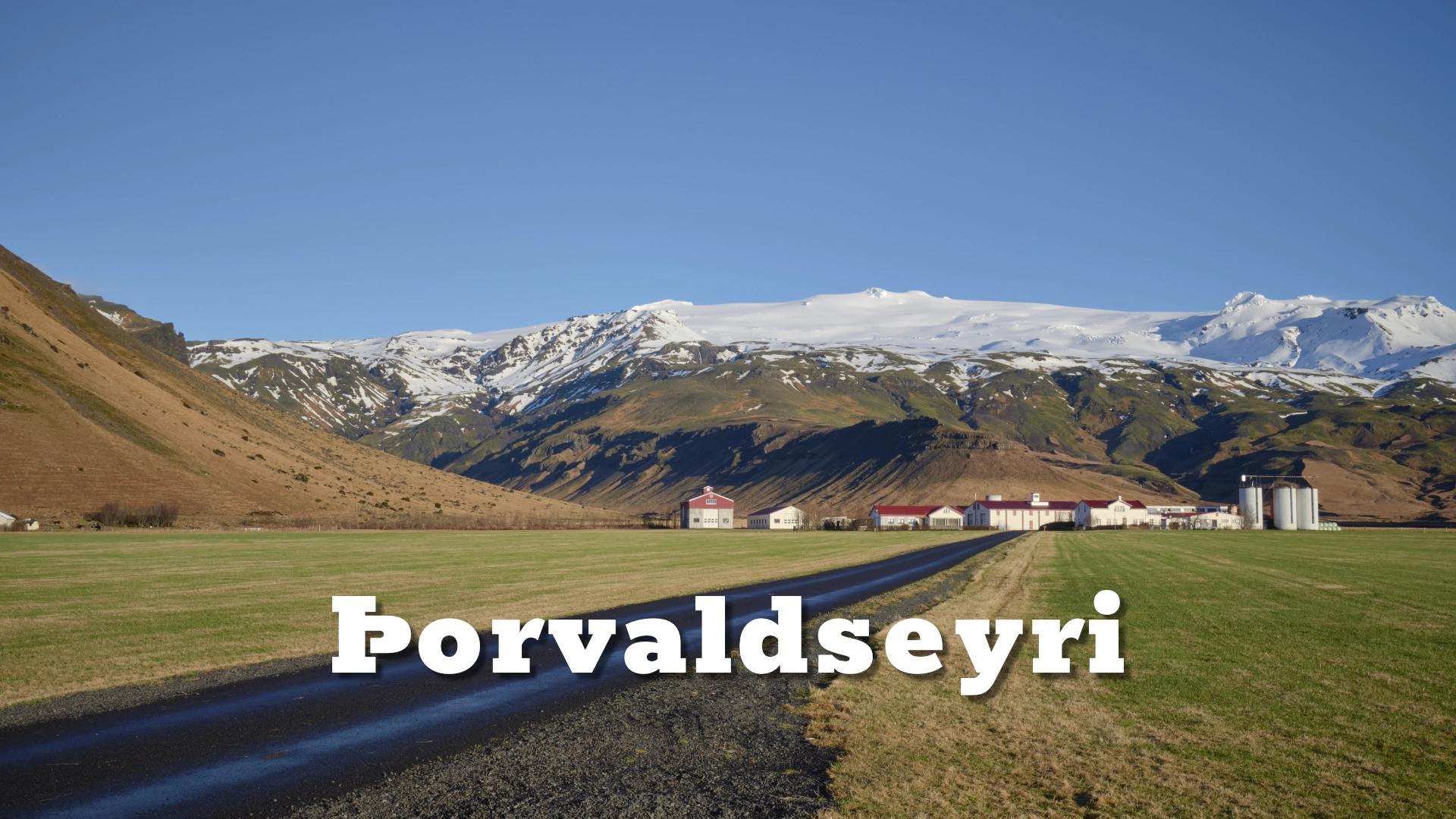
Nestled beneath the shadow of the mighty Eyjafjallajökull volcano in southern Iceland lies the historic farm of Þorvaldseyri, a place steeped in history, resilience, and the captivating beauty of Iceland’s rugged landscape.
The location of Þorvaldseyri farm
Latitude
-19.6677
Longitude
Þorvaldseyri farm
From Svaðbæli to Þorvaldseyri
The land was previously known as Svaðbæli. In 1886, Þorvaldur Bjarnason established a farm here and named it Þorvaldseyri. Twenty years later, in 1906, Ólafur Pálsson bought the farm. His descendants have remained at Þorvaldseyri ever since.
That continuity matters because the history of the farm is not simply a list of owners. Each generation changed how the land was used. The farm developed alongside some of the major changes taking place in Icelandic agriculture during the 20th century.
Older methods remained important, but new machinery, energy sources and crops gradually changed what was possible. Þorvaldseyri became particularly associated with a willingness to try things that were not yet common in Icelandic farming.
A farm built on experimentation
One of the clearest examples is grain. Eggert Ólafsson began experimenting with grain cultivation after 1950, and barley has been grown continuously at Þorvaldseyri since 1960. Later, the farm expanded into wheat and experimented with rapeseed, including its use for cooking oil and fuel.
By around 2000, the farm covered roughly 230 hectares, with about 100 hectares cultivated and around 25 hectares used for grain production.
Agricultural experimentation was only one part of the story. In 1928, Ólafur Pálsson built a small hydroelectric station for the farm. Later generations continued developing their own energy systems.
Geothermal drilling eventually reached hot rock at around 1,000 metres depth, allowing the farm to use geothermal water. The hydroelectric system was also modernised. These projects were practical rather than symbolic: they reduced dependence on outside energy and allowed the farm to keep developing.
By the time Eyjafjallajökull erupted in 2010, Þorvaldseyri was already well known within Icelandic agriculture for trying new approaches. Ólafur Eggertsson received the Icelandic Order of the Falcon in 2009 for his contribution to agriculture and innovation.

April 2010
The first phase of the 2010 Eyjafjallajökull eruption began at Fimmvörðuháls on 21 March. That eruption was spectacular but relatively limited in its effect on Þorvaldseyri.
The situation changed on 14 April, when a new eruption began beneath the ice cap of Eyjafjallajökull. This was the eruption that sent ash high into the atmosphere and disrupted aviation across Europe. For Þorvaldseyri, however, the eruption was not an international news story. It was happening directly above the farm.
Glacial meltwater and flooding affected rivers draining from the volcano. Svaðbælisá flooded near Þorvaldseyri and badly damaged flood defences. Hot-water pipes were broken, leaving the farm without hot water for around four weeks.
Then came the ash. Heavy ashfall covered the farm on 16 and 17 April. Fields, buildings, machinery and roads were coated in dark volcanic material, and the familiar green farmland beneath Eyjafjallajökull became a black landscape.
Farming through the aftermath
The eruption did not end when the ash stopped falling. Ash remained on the land and could be lifted again whenever conditions became dry and windy.
In June 2010, work on the farm continued through the ash. On 1 July, a severe ash storm reduced visibility dramatically. The problem was not only what had fallen from the volcano, but what the wind could repeatedly pick up and move across the farm.
Recovery was therefore gradual. Vegetation began growing through the ash. By August, conditions had improved enough for cattle to return outside, and by September the farm was preparing to harvest wheat.
That sequence says more about the recovery of Þorvaldseyri than broad statements about resilience. The family kept farming.
Some traces of the eruption remain part of the soil and landscape, while others have been softened by cultivation, vegetation, drainage work and more than fifteen years of weather. The farm today does not look like the blackened landscape seen in photographs from April 2010, but the eruption is still part of how the land is managed and understood.
Destination text 5
From eruption exhibition to today
The sudden international attention surrounding Eyjafjallajökull created an unexpected opportunity for Þorvaldseyri. In 2011, the family opened an exhibition telling the story of the eruption from the perspective of the farm beneath it.
That original visitor-centre concept has since changed. The public stop at Þorvaldseyri has developed with a new path, updated signs and a bakery. Visitors can stop, look towards the farm and Eyjafjallajökull, and learn about the place from the public visitor area.
The key distinction is that Þorvaldseyri is still a working farm. The family has embraced its role as a destination, but the farmyard, fields and working areas are not an open-air attraction. Use the signed visitor areas and paths rather than wandering into farm operations.
Visiting Þorvaldseyri
Þorvaldseyri lies directly beside Route 1 between Seljalandsfoss and Skógar. The public roadside stop is the correct destination for visitors and provides the best place to understand the relationship between the farm and Eyjafjallajökull without entering private working areas.
The present visitor stop includes a path, signs and bakery. The volcano dominates the view when weather allows.
Low cloud frequently hides Eyjafjallajökull, so the classic view of the farm beneath the glacier-covered summit should never be assumed. Even without a clear summit, however, the location makes the relationship between farmland and volcano immediately understandable.
Interesting facts:
- Þorvaldseyri was established under its present name in 1886.
- The same family line has farmed there since 1906.
- Barley has been grown continuously at Þorvaldseyri since 1960.
- The farm has also experimented with wheat and rapeseed.
- A small hydroelectric station was built at the farm as early as 1928.
- The farm later developed geothermal energy from a deep borehole.
- Ólafur Eggertsson received the Icelandic Order of the Falcon in 2009 for his contribution to agriculture and innovation.
- Heavy ashfall covered Þorvaldseyri on 16–17 April 2010.
- Flooding from Svaðbælisá damaged flood protection and hot-water pipes during the eruption.
- An eruption exhibition opened at Þorvaldseyri in 2011, and the roadside visitor stop has since evolved.
Image Gallery
Photography tips:
- Þorvaldseyri is best photographed as a relationship between farm and volcano. The classic composition places the farm buildings and cultivated fields in the foreground with Eyjafjallajökull rising behind. A longer focal length can compress the distance between the farm and the mountain, making the volcano appear especially dominant.
- A wider view tells a different story. Including more of the fields and surrounding lowlands shows how the farm sits beneath the broad southern flank of Eyjafjallajökull.
- Weather is often the deciding factor. Low cloud can completely hide the glacier and summit even when conditions at road level are good. When the mountain appears through broken cloud, the changing visibility can be more interesting than a perfectly clear sky.
- The public visitor area should be used as the photographic base. Do not enter fields, farm roads or working areas simply to improve a composition.
- The most important photograph here is not necessarily the closest one. It is the one that explains why farming directly beneath Eyjafjallajökull has shaped the history of Þorvaldseyri.
Destinations nearby