Öræfajökull glacier and volcano
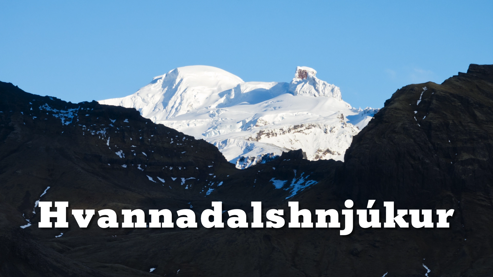
Öræfajökull rises between Skaftafell and Jökulsárlón as one of Iceland’s most imposing mountains. Its broad, ice-covered summit reaches approximately 2,110 metres at Hvannadalshnjúkur, the highest point in Iceland. Beneath the ice is a large stratovolcano with a summit caldera covering approximately 12 square kilometres.
The mountain is connected to the southern edge of Vatnajökull, but it has a clear identity of its own. Numerous outlet glaciers descend from its summit region, including Skaftafellsjökull, Svínafellsjökull, Falljökull, Virkisjökull, Kvíárjökull and Fjallsjökull.
Öræfajökull has erupted only twice since Iceland was settled. Both eruptions occurred beneath the ice and produced destructive jökulhlaups. The first, in 1362, was the largest explosive eruption in Iceland during historical time. It devastated the surrounding district so completely that the region acquired a new name.
Today, most visitors experience Öræfajökull from a distance. The entire mountain can be seen from viewpoints around Skaftafell and across the open landscapes extending east towards Jökulsárlón. Close encounters with its summit and outlet glaciers belong to guided glacier journeys and the separate destinations around its margins.
The location of Öræfajökull glacier and volcano
Latitude
64.016277
Longitude
-16.659723
Öræfajökull glacier and volcano
A volcano beneath the ice
Öræfajökull is a stratovolcano: a high, steep-sided volcanic mountain built through repeated eruptions. It stands outside Iceland’s principal volcanic zones on a separate volcanic belt in the southeast of the country.
The volcano is almost entirely covered by glacier ice. Its summit area contains a caldera, while several peaks and ridges rise through or above the ice around its margins. Hvannadalshnjúkur stands on the north-western rim of this summit region and forms the highest point in Iceland.
Ice moves outwards from the upper mountain into multiple valleys. This creates a ring of outlet glaciers, each with its own shape, rate of movement and surrounding landscape. Some descend in steep icefalls, while others spread into broad tongues bordered by moraines and glacial lagoons.
The mountain’s volcanic and glacial identities cannot be separated. An eruption beneath the summit ice can melt enormous quantities of water in a short period. That water may then escape as a jökulhlaup carrying sediment, volcanic material and blocks of glacier ice towards the surrounding lowlands.
Öræfajökull is therefore both one of Iceland’s great mountains and one of its most consequential volcanic systems.
The eruption that destroyed Litla-Hérað
Before 1362, the settled district around the mountain was known as Litla-Hérað, meaning the little district or county. It was also described as Hérað milli sanda—the district between the sands—because it lay between the great glacial outwash plains of Skeiðarársandur and Breiðamerkursandur.
In 1362, Öræfajökull produced the largest explosive eruption in Iceland since the country was settled. Approximately ten cubic kilometres of volcanic material were ejected, and tephra from the eruption was distributed across much of Iceland.
The effects close to the volcano were catastrophic. Heavy tephra fall, pyroclastic flows and jökulhlaups devastated the inhabited land around the mountain. Farms were buried or destroyed, grazing land disappeared and the established settlement collapsed.
The eruption did more than damage individual farms. It interrupted life throughout the district and temporarily turned cultivated land into a desolate volcanic landscape. Litla-Hérað gradually became known as Öræfi, a name associated with wilderness, wasteland or land without a harbour.
Settlement eventually returned, but the new name remained. Öræfajökull can therefore be described as the volcano that named the region surrounding it.
The scale of the eruption is difficult to recognise in today’s green farmland. Much of the landscape has recovered, and generations of farmers rebuilt communities beneath the mountain. The name Öræfi preserves the memory of the disaster even where its physical evidence is no longer immediately visible.

The eyewitness account from 1727
Öræfajökull erupted again in August 1727. This eruption was considerably smaller than the event of 1362, but its interaction with the glacier still produced a destructive jökulhlaup.
A detailed account survives from Jón Þorláksson, the parish priest at Sandfell. His description makes the 1727 event one of Iceland’s most vividly recorded historical eruptions.
Earthquakes were felt before the eruption. The glacier appeared to swell and change before a tremendous cracking sound was heard from the mountain. Floodwater then burst from beneath the ice and rushed onto the lowlands, carrying mud, sediment and enormous pieces of glacier ice.
The jökulhlaup followed routes between the mountain and the settled land around Sandfell and Hof. Three people died, livestock was lost and farms and grazing land were damaged. Blocks of ice deposited on the outwash plain remained there for years; some were reportedly still visible almost three decades later.
Jón Þorláksson survived and left an account from the perspective of someone living directly beneath the volcano. His observations provide an unusual human record of the earthquakes, sounds, moving ice and sudden flood that accompanied an eruption beneath a glacier.
The 1727 eruption was the most recent eruption of Öræfajökull. A period of increased seismic and geothermal activity beginning in 2017 led to intensified scientific monitoring, although no eruption followed. The volcano continues to be monitored by the Icelandic Meteorological Office.
Hvannadalshnjúkur and the summit
Hvannadalshnjúkur rises to approximately 2,110 metres on the edge of the Öræfajökull summit region. It is Iceland’s highest point and one of the highest volcanic summits in Europe.
From the lowlands, the precise summit is not always easy to identify. Öræfajökull appears as a broad complex of ice, ridges and subsidiary peaks rather than a single isolated cone. Cloud frequently gathers around the upper mountain, concealing Hvannadalshnjúkur while lower glacier tongues remain visible.
The usual climbing route begins near Sandfell. Reaching the summit is a serious glacier journey involving a long ascent, crevassed terrain and rapidly changing mountain weather. Climbers require appropriate glacier equipment, navigation skills and knowledge of current conditions. For most visitors, joining a qualified guide is the appropriate way to attempt the ascent.
Hvannadalshnjúkur has its own destination page containing the practical information required for the climb. On this page, the summit is important as the highest point of the greater Öræfajökull mountain and as part of the rim surrounding its ice-filled caldera.
A mountain of many glaciers
The outlet glaciers descending from Öræfajökull reveal different parts of the same mountain.
Skaftafellsjökull and Svínafellsjökull descend on its western and north-western sides. Falljökull and Virkisjökull flow southwards through steep valleys, while Kvíárjökull spreads below the mountain’s south-eastern slopes. Fjallsjökull reaches towards its lagoon farther east.
These outlets make it possible to study Öræfajökull at a closer scale. Their icefalls, crevasses, moraines, lagoons and retreating fronts show processes that are difficult to recognise when looking at the complete mountain from a distance.
Several outlets are established destinations and should be treated separately. Falljökull is associated with guided glacier walks, while Fjallsjökull is known for its broad glacier front and lagoon. Kvíárjökull has a short approach through a landscape dominated by large moraines.
The retreat of these glaciers is gradually changing the lower slopes of Öræfajökull. New ground, lakes and drainage channels appear as the ice withdraws. The mountain remains immense, but its margins record substantial and continuing environmental change.
Experiencing Öræfajökull
Öræfajökull is best experienced as a major feature of the wider landscape rather than as a single roadside attraction.
Skaftafell provides strong views of the mountain’s western side. From clearings, roads and trails in the area, the glacier-covered summit rises behind lower ridges and outlet glaciers. The view also places Öræfajökull within the western part of the region it transformed in 1362.
East of the mountain, the open country towards Jökulsárlón offers broader and more distant views. From this direction, Öræfajökull can dominate the western skyline above farmland, outwash plains and the lower margins of Vatnajökull.
Route 1 passes around the southern base of the mountain, but there is no single roadside stop that explains Öræfajökull completely. Its scale becomes clearer while travelling through the entire region from Skaftafell towards Jökulsárlón.
Visitors should not attempt to walk onto the glacier independently. The upper mountain and its outlet glaciers contain crevasses, unstable ice and complex routes. Close glacier travel and summit journeys require suitable equipment, experience and, for most visitors, professional guidance.
Interesting facts:
- Öræfajökull is an ice-covered stratovolcano connected to the southern edge of Vatnajökull.
- Its summit caldera covers approximately 12 square kilometres.
- Hvannadalshnjúkur, approximately 2,110 metres high, is Iceland’s highest point.
- Öræfajökull has erupted twice since Iceland was settled, in 1362 and 1727.
- The 1362 eruption was Iceland’s largest explosive eruption during historical time.
- Approximately ten cubic kilometres of volcanic material were produced in the 1362 eruption.
- The district surrounding the volcano was called Litla-Hérað before the 1362 disaster.
- The devastation led to the region becoming known as Öræfi.
- Parish priest Jón Þorláksson left a detailed eyewitness account of the 1727 eruption and jökulhlaup.
- Three people died during the 1727 eruption.
- Huge blocks of glacier ice carried onto the lowlands in 1727 remained visible for many years.
- Öræfajökull feeds numerous outlet glaciers, including Skaftafellsjökull, Svínafellsjökull, Falljökull, Virkisjökull, Kvíárjökull and Fjallsjökull.
Image Gallery
Photography tips:
- Use viewpoints around Skaftafell to photograph the western side of Öræfajökull above woodland, low ridges and outlet glaciers.
- The open landscapes between Skaftafell and Jökulsárlón provide distant views that communicate the full scale of the mountain.
- A moderate telephoto lens helps isolate Hvannadalshnjúkur, summit ridges and icefalls from distant viewpoints.
- Use a wider lens when farmland, glacial rivers or the outwash plains help explain the mountain’s place within Öræfi.
- Morning and evening side light can reveal ridges and glacier structure that disappear under flatter midday illumination.
- Öræfajökull frequently collects cloud. Openings in low or broken cloud can produce more dramatic photographs than a completely clear sky.
- From the Jökulsárlón area, look west for the mountain rising beyond the broad glacial landscape.
- Snow conditions and atmospheric haze strongly affect contrast. A polarising filter may help in some conditions, although its effect can become uneven with very wide lenses.
- Include buildings, trees or vehicles where appropriate to provide a sense of scale.
- Photograph individual outlet glaciers separately as details of the greater Öræfajökull system.
- Never enter glacier terrain merely to find a stronger composition. Close work on the ice should only be undertaken with appropriate equipment and guidance.
Destinations nearby