Höfn Í Hornafirði
Höfn sits on a low peninsula between Hornafjörður and Skarðsfjörður in southeastern Iceland. It is the largest settlement between Vík and Djúpivogur and an important centre for the communities, farms and travellers of the region. It also stands at a transition between two different parts of the country. To the west are the broad glacial landscapes and outwash plains of southern Iceland; continuing east, the road enters a more confined coastline of steep mountains and narrow fjords.
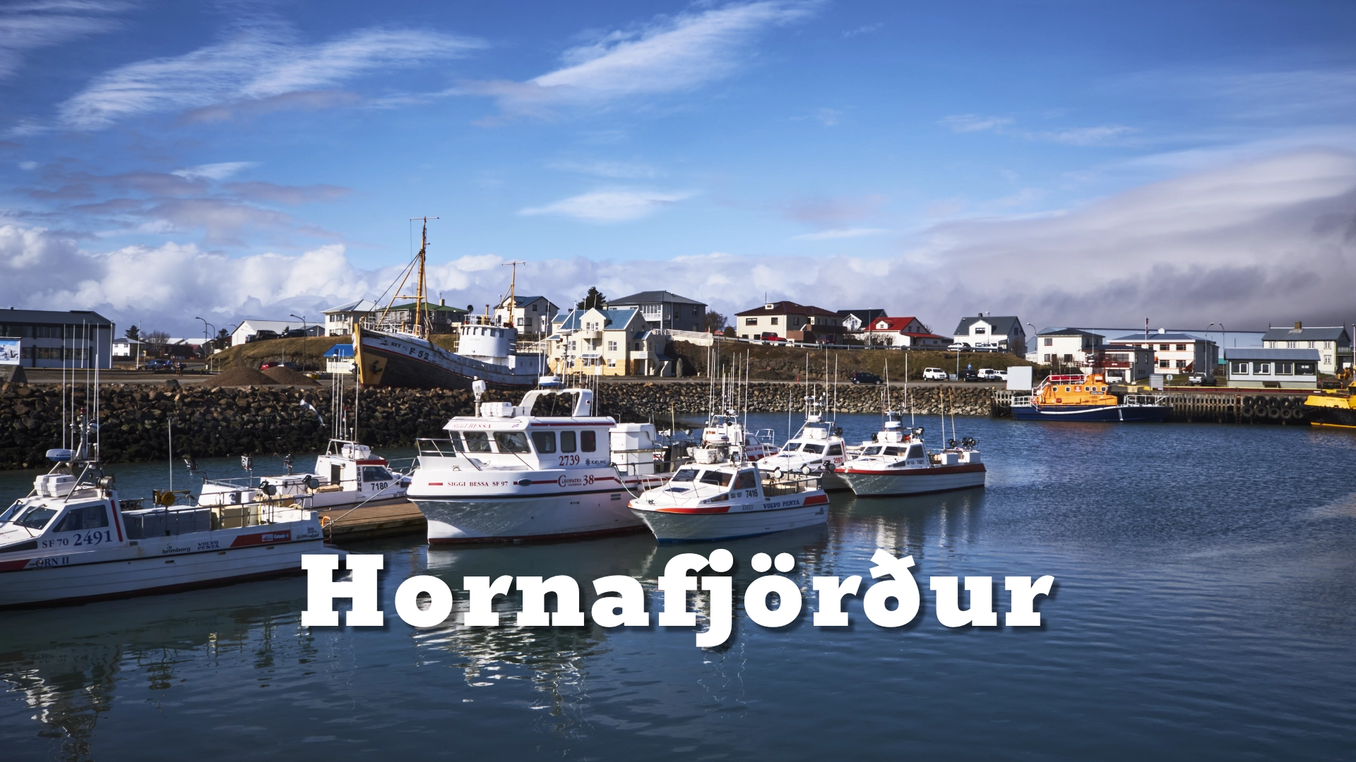
Like many Icelandic coastal towns, Höfn developed around its harbour and remains closely tied to fishing. What distinguishes it is the coastline. Walking paths follow the shore, bringing fishing boats, harbour buildings and the open water into the same view as the distant mountains and ice. Höfn is a working harbour town shaped by fishing, but distinguished by a coastline where the harbour, ocean and glaciers form part of the view from the town itself.
The location of Höfn Í Hornafirði
Latitude
64.248602
Longitude
-15.205293
Höfn Í Hornafirði
A town shaped by its harbour
The harbour is both the physical and economic centre of Höfn. Fishing and fish processing have long supported the town, and one of Iceland’s stronger fishing companies is based here. The industry has never depended on a single species; the harbour serves a broader fishing economy whose vessels and processing operations connect Höfn to fishing grounds around the country.
Reaching the harbour from the sea is not straightforward. The entrance to Hornafjörður is shallow and affected by moving sandbanks, making local knowledge and careful navigation important. This difficult approach is part of the maritime reality behind the working boats seen along the waterfront.
Höfn is not simply a service stop beside the Ring Road. It is a working town whose position has always been shaped by the water around it and by access to the sea.
A coastline facing the glaciers
Paths around the peninsula make the shoreline one of the most accessible parts of Höfn. They lead past the harbour and along the edge of the fjords, opening broad views over water, coastal flats and the mountains beyond.
In clear conditions, several outlet glaciers of Vatnajökull can be seen from the town. Their appearance changes with distance, cloud and light: sometimes the ice is a dominant band below the mountains; at other times it becomes a pale detail on the horizon. Wider views show how the town, fjord and glacier landscape relate to one another.
The paths also connect the harbour with quieter stretches of coast, public art and monuments. On clear, dark nights, parts of the waterfront with limited direct lighting can provide open views of the northern sky. The coastline is therefore not only a viewpoint but part of daily life in Höfn—a place for walking, looking across the fjord and watching weather move between the ocean and the ice cap.

Höfn and the langoustine
Höfn has become widely associated with Icelandic langoustine, known locally as humar. The annual Humarhátíð festival helped make that association part of the town’s public identity, but langoustine was never the sole foundation of Höfn’s fishing economy.
The fishery declined as the stock weakened, and commercial langoustine fishing was stopped in 2022. After several years without a local catch, limited research fishing took place in 2026 when surveys showed an increase in the number of langoustine burrows. Some of that catch was served during Humarhátíð, bringing locally caught langoustine back to the festival.
The research catch is an encouraging sign, but it is not a full reopening of the commercial fishery. The stock remains under assessment. Höfn’s connection with langoustine therefore continues through its food culture and festival, while the town’s working fishing industry remains much broader.
Culture and regional life
Höfn serves a wide and sparsely populated part of southeastern Iceland. The town provides public services, shops, accommodation, restaurants, a municipal swimming pool, a campsite and an airport, but individual businesses change and are best checked through current local information.
Beside the harbour, the historic timber building Gamlabúð houses the Höfn visitor centre and an exhibition about the region’s glaciers, geology and culture. Menningarmiðstöð Hornafjarðar is the municipality’s cultural institution, responsible for activities and collections that include the library, archives, regional collection and art collection.
Humarhátíð is held annually and remains one of the events most closely associated with Höfn. Together, these institutions and events show a town that functions not only as a base for exploring the southeast, but as the cultural and administrative centre of the region.
Between the south and the east
Höfn’s position between southern and eastern Iceland has shaped the town in more than a geographical sense. Before 1974, the glacial rivers and outwash plains of Skeiðarársandur prevented a continuous road connection along the south coast. Travellers heading east from the southwest could sail from Þorlákshöfn to Höfn. Even a journey to Skaftafell could involve arriving at Höfn by sea and then driving back west.
The opening of the bridges across Skeiðarársandur in 1974 completed the Ring Road around Iceland and changed Höfn’s relationship with the rest of the country. A town that had served as a maritime gateway became part of the continuous road linking the south coast with the Eastfjords.
That role is still visible today. From Höfn eastward, the landscape changes dramatically: the broad glacial lowlands give way to mountains that descend towards narrow fjords, with settlements occupying relatively small areas between mountain and sea. Höfn consequently feels like a bridge between the south and the east—the point where one Icelandic landscape begins to give way to another.
Tourism has strengthened this position. Travellers use Höfn as a base for the glaciers and lagoon landscapes to the west, Stokksnes and Vestrahorn nearby, and the coastal route into the Eastfjords. Accommodation, restaurants and visitor services have expanded alongside this traffic and contributed to the town’s recent growth. Yet Höfn has not become solely a tourist settlement. Fishing, fish processing and its role as a regional service centre remain fundamental to the life of the town.
Höfn as a base in the southeast
Höfn lies within reach of several different southeastern landscapes, but realistic driving times matter. Stokksnes and Vestrahorn are approximately fifteen minutes east of town. Hoffell lies about 20 kilometres inland, while Jökulsárlón is roughly an hour’s drive to the west. Djúpivogur is about an hour and a half to the east, depending on road and weather conditions.
These places are separate destinations rather than parts of Höfn itself. The town’s own harbour, shoreline and glacier views deserve time before travelling onward. Shared access information for Vestrahorn, the beach and the Viking village is covered on the Stokksnes page, where current arrangements can be explained without duplicating them here.
Interesting facts:
- Höfn is the largest settlement between Vík and Djúpivogur.
- The town occupies a low peninsula between Hornafjörður and Skarðsfjörður.
- Before the bridges across Skeiðarársandur opened in 1974, travellers from southwestern Iceland could reach Höfn by sea from Þorlákshöfn.
- The 1974 bridges completed the Ring Road and transformed Höfn from a maritime gateway into part of the continuous road connection between southern and eastern Iceland.
- Fishing and fish processing remain central to the local economy.
- Tourism has contributed to recent growth, but Höfn remains a working fishing town and regional service centre.
- The entrance to Hornafjörður is shallow and affected by shifting sandbanks.
- Höfn is strongly associated with langoustine, although its fishing economy has always been broader.
- Commercial langoustine fishing was stopped in 2022; limited research fishing took place in 2026 after surveys indicated encouraging signs in the stock.
- Gamlabúð beside the harbour now houses the visitor centre and a regional exhibition.
- Vatnajökull and several of its outlet glaciers can be seen from the town in clear conditions.
Image Gallery


Photography tips:
- The harbour combines working boats, waterfront buildings and views across Hornafjörður.
- Longer focal lengths can emphasise individual glacier outlets, while wider views show their relationship to the town, fjord and mountains.
- Shoreline paths provide changing angles towards the harbour, ocean and ice cap without requiring travel outside the town.
- Reflections, tidal water and changing weather can alter the balance between foreground, town and distant glaciers.
- Public art, monuments and everyday harbour activity offer subjects beyond the wider landscape.
- On clear winter nights, the waterfront can provide foregrounds for northern-lights photographs where direct street lighting is limited.
Destinations nearby